5 satellite cities help alleviate congestion in Ho Chi Minh City center.
Ho Chi Minh City - Thu Duc City is a highly interactive and innovative urban area in the East; Can Gio is a coastal ecological urban area; the southern urban area has Phu My Hung as its center; the southwestern urban area (Binh Chanh) is a gateway to the Mekong Delta; and the northwestern urban area is a gateway connecting to Binh Duong, Tay Ninh, and Cambodia.
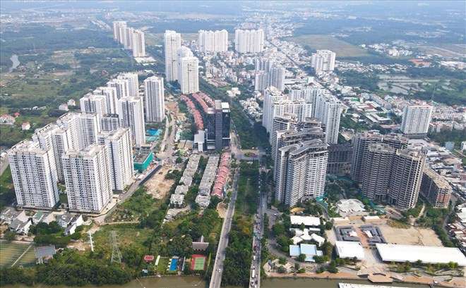
The suburban areas of Ho Chi Minh City are developing in a "spreading oil stain" pattern.
These five urban areas will be updated in the revised master plan for the construction of Ho Chi Minh City until 2040, with a vision to 2060, helping to alleviate pressure on the existing central area and open up new development spaces.
Things we haven't been able to accomplish in 25 years.
Developing Ho Chi Minh City into a satellite city is a goal the city has pursued for the past 25 years. The concentrated-multipolar model, established in 1998, uses the inner city as the central area with a radius of 15 km and is designed with four development poles. Accordingly, the existing central area (930 hectares) includes Districts 1, 3, 4, and Binh Thanh.
The four development directions include: the main direction to the East, which is the current Thu Duc City (the high-interaction, creative urban area in the East); the main direction to the South, which includes Districts 4, 7, 8, Nha Be District, and Can Gio District; the secondary direction to the Northwest, which includes District 12, Hoc Mon District, and Cu Chi District; and the secondary direction to the West-Southwest, which includes parts of Districts 7, 8, and Binh Chanh District.
However, the current situation shows that, apart from the old inner city which is the existing center, the adjacent areas are developing in a "spreading oil stain" pattern, and have not yet formed development hubs in any direction.
In particular, the main eastern direction has not yet seen the formation of large-scale, integrated urban areas. In reality, the numerous small-scale investment projects, scattered in location, significantly affect the connectivity of technical and social infrastructure.

Thu Duc City has not yet developed large, integrated urban areas.
In the southern direction, the infrastructure along the main Nguyen Huu Tho road is basically complete. Development projects along this route are concentrated within the southern boundary, extending to the surrounding areas. Although this direction shows a development trend, it is still slow. Specifically, the Hiep Phuoc urban area, since the approval of the general planning project, has not yet completed the 1/2,000 scale zoning plan.
In the Northwest direction, with the Northwest Urban Area as the development hub, although the general plan and the 1/2,000 scale zoning plan have been completed, urban and residential area projects are progressing very slowly or not at all. Examples include the Tan Thoi Nhi and Tay Hiep urban residential areas, the Vietnam International University (VIUT) urban area, and the District 12 ecological urban area.
The secondary routes to the West and Southwest, along with the main North-South transportation axes of Ho Chi Minh City and the ring road, have not yet been fully connected or invested in.
Develop 5 satellite cities based on the TOD model.
Given the above situation, in the upcoming planning adjustment, instead of developing Ho Chi Minh City in two main directions and two secondary directions as before, the city aims for a balance across all four directions - East, South, Northwest, and Southwest.
In addition, five suburban districts (Hoc Mon, Cu Chi, Binh Chanh, Nha Be, and Can Gio) are slated for upgrading to urban districts or cities.
Ho Chi Minh City is a multi-centered urban area with a Transport-Oriented Development (TOD) orientation, gradually reducing pressure on the central area, aiming to form and develop "satellite" urban areas, linked to prominent urban functions within the overall Ho Chi Minh City and surrounding metropolitan area.
The five satellite urban areas include: Thu Duc City, a smart, innovative, and highly interactive urban area in the East; Can Gio, an ecological urban area and a gateway for international trade via sea; the Southern urban area with Phu My Hung as its center; the Southwestern urban area, a gateway connecting to the Mekong Delta; and the Northwestern urban area, a gateway connecting to Binh Duong, Tay Ninh, and Cambodia.

Ho Chi Minh City will develop Can Gio into an ecological urban area.
On August 26th, Ho Chi Minh City Party Secretary Nguyen Van Nen and Chairman of the Ho Chi Minh City People's Committee Phan Van Mai took a helicopter survey to gather information for the development of Ho Chi Minh City's urban planning.
Speaking to the press after the survey trip, Mr. Phan Van Mai said that the allocation and use of land still have many shortcomings and inefficiencies, with many areas having a patchwork of land. This raises issues for future planning, requiring restructuring of production and residential areas to maximize the efficiency of land use.
The Chairman of the Ho Chi Minh City People's Committee stated that urban development is linked to the TOD (Transit-Oriented Development) model. Following the issuance of Resolution 98 by the National Assembly, Ho Chi Minh City reviewed the spaces along the Ring Roads 2 and 3, Metro Lines 1 and 2, and expressways. Through this review, the city identified numerous areas suitable for developing the TOD model.
"These are the central cores of Ho Chi Minh City's future urban area. We see enormous potential to both develop land resources and restructure the city's multi-centered urban model," Mr. Mai said.
Communicated by An Huy Group
Related News

High interest rates and restructuring in the real estate market.
(VNF) - Floating mortgage interest rates, remaining at 11%-14% per year, and even reaching 15%-16% for some loans, are causing the real estate market to enter a strong consolidation phase. As capital costs erode profits and debt repayment pressure increases, investment capital is also beginning to shift to safer segments with the potential to generate good cash flow.
View Details
Interest rate is only 5.4%/year: Who is eligible to borrow to buy social housing at the Social Policy Bank?
The Vietnam Social Policy Bank (VSPB) is implementing a preferential loan program for those buying or renting social housing, as well as for some cases of new construction, renovation, or repair of housing. According to current regulations, the loan interest rate is 5.4% per year, with a maximum loan term of 25 years.
View Details
High Interest Rates Reshape the Real Estate Market, Shifting Focus to Selective Investment
Mortgage lending rates remained at 12–14% during the first half of 2026, placing significant pressure on liquidity in the real estate market.
View Details
Interest rates exceed 9% again: What will the real estate market be like at the end of the year?
(Inspection) - Deposit interest rates are heating up again, with some banks offering rates exceeding 9% per year. This development is expected to put further pressure on the real estate market in the second half of 2026, as capital costs increase, mortgage interest rates remain high, and liquidity continues to face many challenges.
View Details
The income ceiling for purchasing social housing will officially be raised to 25 million VND/month from April 7, 2026.
(Chinhphu.vn) - In Decree No. 136/2026/ND-CP, the Government stipulates raising the income ceiling for individuals purchasing social housing to 25 million VND/month.
View Details
From July 1st, 2026, what will be the interest rate for loans to purchase social housing for people under 35 years old?
Given the high interest rates on commercial home loans, the preferential credit policy effective from July 1, 2026, is expected to help young people reduce financial pressure and increase their access to social housing. So, from July 1, 2026, what will be the interest rate for loans to purchase social housing for those under 35 years old?
View Details
Officially adding a priority group for purchasing social housing.
From July 1, 2026, people with two or more children will be prioritized to buy, lease-to-own, or rent social housing according to the new regulations.
View Details
From July 1st, customers under 35 years old at Vietcombank, Agribank, BIDV, VietinBank, MB, etc., will all receive good news.
From July 1st to December 31st, 2026, people under 35 years old who borrow to buy social housing will enjoy preferential interest rates.
View Details
Announcement of the revised Tay Ninh 2030 planning: New administrative center in Duc Hoa - Hau Nghia.
According to the plan, the Tay Ninh Provincial Political and Administrative Center will be located in the northern area of Duc Hoa - Hau Nghia urban area. The specific construction location will be studied and proposed based on ensuring requirements for spatial development, connectivity, and synchronization of technical infrastructure and transportation systems of the province and the Southeast region.
View Details
The important role of 5 satellite cities for Ho Chi Minh City.
Ho Chi Minh City will develop five satellite cities to alleviate population density and address a range of related issues such as traffic, pollution, and quality of life.
View Details
Ho Chi Minh City develops satellite cities.
The satellite cities in Ho Chi Minh City that will be formed after 2030 will not follow the mechanical process of upgrading districts to cities, but rather will be independent urban clusters connected via urban rail.
View Details
Chairman of Ho Chi Minh City: Develop 5 satellite cities based on the TOD model.
Besides Thu Duc City, Ho Chi Minh City is also developing four other satellite cities associated with the Transport-Oriented Development (TOD) model, including Can Gio, the South, Southwest, and Northwest areas.
View Details
Real Estate Outlook 2026: From Global Trends to Growth Drivers in Vietnam
Entering 2026, the global real estate market is showing positive signs again, amidst a gradually stabilizing economy with new drivers, especially technology and artificial intelligence (AI).
View Details
The legal framework expands opportunities for overseas Vietnamese to invest in real estate in Vietnam.
According to data from the State Bank of Vietnam – Regional Branch 2, in the first nine months of 2025, Ho Chi Minh City recorded approximately US$7.94 billion in remittances, accounting for nearly 60% of the total remittances nationwide. The main sources of remittances were Asia (50%) and the Americas (30%).
View Details
Fluctuations in capital costs and the adaptation challenge for homebuyers.
The upward adjustment in mortgage interest rates is making many buyers and investors more cautious in making financial decisions. According to experts, this is not a negative signal for the real estate market, but rather a factor that promotes a more sustainable adjustment process.
View Details
With abundant supply, the real estate market reflects a trend of diversified capital flows.
The widespread increase in supply, with a growing diversity of product types and price ranges, gives buyers more choices, while also making the trend towards selectivity more pronounced.
View Details
Understanding the property identification code applicable from March 1st.
From March 1st, 2026, electronic property identification codes will be issued to each property. So what do people need to know about the property identification codes that will be applied from March 1st?
View Details
Tay Ninh will relocate its new administrative and political center to Duc Hoa - Hau Nghia.
The Chairman of the People's Committee of Tay Ninh province, Le Van Han, has just signed and issued the revised Provincial Planning for the period 2021–2030, with a vision to 2050, aiming to shape a new development space and take advantage of its location bordering Ho Chi Minh City, Dong Nai, Dong Thap, and Cambodia.
View Details
Determined to increase market transparency and "close the gaps" in real estate transactions.
Recently, Prime Minister Pham Minh Chinh directed the urgent pilot operation of a cryptocurrency exchange platform, and simultaneously established a State-managed Real Estate and Land Use Rights Transaction Center, with the goal of implementation in February 2026. This is a strong move, clearly demonstrating the Government's determination to restructure and increase transparency in the real estate market…
View Details
Expedite the finalization of documents for establishing a Real Estate and Land Use Rights Transaction Center; strictly control speculative real estate credit.
(Chinhphu.vn) - Prime Minister Pham Minh Chinh directed the urgent completion of the dossier for the establishment of a Real Estate and Land Use Rights Transaction Center; and requested strict control over speculative real estate credit, focusing on the actual housing needs of the people.
View Details
What Does the World Say About Vietnam's Real Estate Market?
In the context of Vietnam's real estate market moving beyond a period of profound adjustment and facing the imperative for comprehensive restructuring, the narrative of sustainable development is no longer merely a guiding slogan but has become a practical challenge of existential importance.
View Details
Tay Ninh Master Plan 2030: Duc Hoa – Hau Nghia OFFICIALLY Approved as Provincial Political and Administrative Center
At the 9th Session (specialized session) of the 10th Legislature, the People's Council of Tay Ninh Province officially adopted a Resolution on Adjusting the Tay Ninh Provincial Master Plan for the period 2021-2030, with a vision to 2050. The most significant highlight of this revised master plan is the designation of the Duc Hoa – Hau Nghia urban cluster as the new political and administrative center of the province, marking a strong transformation in the organization of development space following provincial consolidation.
View Details
Sharp increases in land plot prices are observed, and the market is projected to witness an explosion of supply in 2026.
Land plot prices are set to keep increasing through 2025, as demand clearly improves and new supply is anticipated to make a strong comeback in 2026.
View Details
Legal Transparency Becomes An Huy Group's Competitive Advantage
Recently, An Huy Group distinguished itself by successfully meeting the stringent selection criteria to receive the "Top 10 Distinguished Legally Transparent Real Estate Enterprises" award.
View Details
An Huy Group was honored as one of the “Top 10 Real Estate Enterprises with Outstanding Legal Transparency.”
Recently, at the announcement ceremony of the “Asia-Pacific Excellent Brand 2025”, Cong ty Dia oc An Huy (An Huy Group) successfully surpassed stringent evaluation criteria to receive the award “Top 10 Real Estate Enterprises with Outstanding Legal Transparency.”
View Details
An Huy Group was honored as one of the “Top 10 Real Estate Enterprises with Outstanding Legal Transparency.”
Recently, at the announcement ceremony of the “Asia-Pacific Outstanding Brand 2025”, Cong ty Dia oc An Huy (An Huy Group) successfully met and surpassed stringent evaluation criteria to receive the award “Top 10 Real Estate Enterprises with Outstanding Legal Transparency.”
View Details
Announcement of Report: Real Estate in Tay Ninh Province After the Merger – Synergistic Strengths and Breakthrough Opportunities
On November 6, 2025, the Vietnam Real Estate Research Institute (VIRES) officially released the market report: "Real Estate in Tay Ninh Province After the Merger – Synergistic Strengths and Breakthrough Opportunities."
View Details
Pickleball Cup An Huy 2025 – 1st Edition: Spreading the Spirit of Sports, Connection, and Sharing
At noon on November 8, 2025, the atmosphere at the four Pickleball courts in An Huy My Viet Urban Area (Rung Sen Hamlet, Duc Lap Commune, Tay Ninh Province – formerly part of Duc Hoa District, Long An Province) became lively and exciting as the 1st An Huy Pickleball Cup – 2025 officially kicked off.
View Details
Upcoming Market Report Release: "Tay Ninh Province Real Estate After the Merger – Synergistic Strength and Breakthrough Opportunities"
Scheduled for November 6, 2025, the Vietnam Real Estate Research Institute, in collaboration with Vietnam Real Estate Online Magazine, will release the Market Report: "Tay Ninh Province Real Estate After the Merger – Synergistic Strength and Breakthrough Opportunities."
View Details
The Steadfast Advancement of An Huy Group with the Honor of “Asia’s Leading Trusted Brand 2025”
The title “Asia’s Leading Trusted Brand 2025,” recently awarded to An Huy Group, marks a proud milestone that recognizes the company’s more than two decades of steadfast effort in affirming the stature of a Vietnamese brand.
View Details
The An Huy My Viet Project wins the Best Township Heritage Landscape Design Vietnam 2024 award.
At the DOT Property Vietnam Awards 2024 ceremony held on September 26, 2024, the An Huy My Viet Project, developed by An Huy Group, excelled in winning the “Best Township Heritage Landscape Design Vietnam 2024” award.
View Details
BIDV Bank and An Huy Group Sign Credit Financing Partnership Agreement
On September 6, 2024, the Bank for Investment and Development of Vietnam (BIDV) and An Huy Real Estate Joint Stock Company (An Huy Group) held a signing ceremony to establish a partnership supporting customers in obtaining financing when purchasing real estate products at the An Huy My Viet Urban Area.
View Details
Notice: Warning Against Fraudulent Use of the An Huy Group and An Huy My Viet Brands
Currently, An Huy Group is developing the An Huy My Viet Urban Area in My Hanh Bac Commune, Duc Hoa District, Long An Province. The An Huy My Viet Project has officially commenced construction and is being implemented in strict compliance with current real estate investment laws and regulations.
View Details